


The Institution of Surveyors of Kenya (ISK) has said that deforestation, unsustainable land use, and poor settlement planning have increased the frequency and severity of landslides in Kenya.
According to ISK, the continued deforestation had weakened soil structures, destabilised slopes, and compromised the natural drainage systems that prevent such disasters.
ISK President Erick Nyadimo said that Kenya has recorded over 120 landslide events in the past decade, with Elgeyo Marakwet being among the top five high-risk counties.
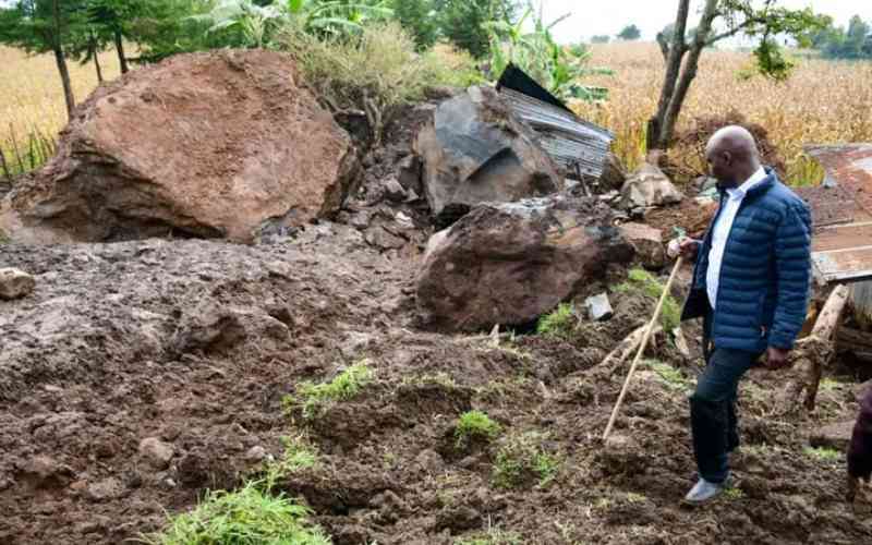
At least 26 people have been confirmed dead after mudslides struck Elgeyo Marakwet County last week in the Murkutwa, Chesongoch, Kabetwa, and Embobut areas of Marakwet East.
Over a dozen are missing, while 500 families were displaced after rivers burst their banks, triggering night-long deluges.
While extending his condolences to victims of the landslide, Nyadimo called on Kenyans to stop the culture of clearing forests for farming, grazing, charcoal burning, and settlement.
“While the Government’s plan to plant 15 billion trees by 2032 through the National Tree Growing Restoration Campaign is commendable, this effort must go hand in hand with strict enforcement of land-use planning, conservation, and settlement control measures. Otherwise, these noble goals will remain unattained aspirations,” said Nyadimo.
He said the tragedy in Elgeyo Marakwet is a painful reminder of the growing vulnerability of communities living in landslide-prone regions and the urgent need for coordinated national action on disaster preparedness and sustainable land management.
Nyadimo said that it is regrettable that despite the early warnings issued by the Kenya Meteorological Department, lives were still lost due to limited evacuation planning, poor infrastructure, and the absence of designated temporary shelters for residents in high-risk zones.
“This situation demonstrates a critical gap in our disaster management framework, where early warnings are not consistently followed by effective preventive or mitigated measures,” said Nyadimo.
The surveyors recommended mapping and zonation of landslide-prone areas.
The President said the Government, through relevant ministries, departments and agencies, should work with professional bodies like ISK to conduct detailed geospatial mapping to identify, classify, and monitor high-risk areas across the country.
Nyadimo said that county governments should strictly prohibit human settlement and development in identified high-risk zones and enforce buffer zones along slopes, rivers, and forested areas.
“The national and county disaster management units must operationalise early warning systems by linking meteorological alerts to immediate community-level actions, including evacuation and provision of temporary shelters.
Stay informed. Subscribe to our newsletter
The surveyors also recommended the restoration of forest and catchment areas by intensifying reforestation and afforestation programmes, enforcing anti-logging regulations, and promoting sustainable agricultural practices to stabilise soil and protect watersheds.
Nyadimo called for community awareness and capacity building through educating residents in vulnerable areas on environmental conservation, disaster response, and safe settlement practices to empower communities to take preventive measures.
“We must treat this tragedy as a wake-up call to prioritise environmental conservation, proactive planning, and responsible land use, not only to honour the lives lost but also to prevent such avoidable disasters in the future,” said Nyadimo.